Something for your "low-mo" day, sir?
Sunday's weather was predicted to be excellent and I wanted to be out in the mountains. However, it was a "low-motivation" day; nothing seemed to pique my interest. From past experience, low-mo is instantly cured the moment my feet touch the trail. The biggest hurdle to overcome is getting from home to trail-head.January's Grid list offered many challenging destinations but I wasn't in the mood for them. I wanted a sub 8 hour hike so I chose Colvin and Blake with a side-order of Fish Hawk Cliffs and a glass of Indian Head.
I left my home at 5:00 AM. The US Customs and Border Protection officer subjected me to an unusually long list of questions. The dozen or so inquiries ranged from the usual, such as destination and purpose of visit, and then probed deeper to frequency of entry, employment status, vehicle's owner, and wife's occupation. I felt his question about why my wife had not joined me was a little over the top. Nevertheless, I responded politely and was granted entry.
Sunrise was an hour away and the night sky treated me to the full moon low in the west and five planets in the east (Mercury, Venus, Saturn, Mars, and Jupiter). However, I only identified four planets and missed Mercury.
I made good time and rolled into the St-Huberts parking area at 7:00 AM. I spent about fifteen minutes prepping for the day. I'd be trying something different to keep my hands warm. Normally I use a combination of fleece mitts, liner gloves, and chemical hand-warmers. Nevertheless, I'm still prone to developing painfully cold fingers especially after extracting my gloved hands to perform a task (like operate a camera). Today, my first line of defense would be a vapor-barrier in the form of a pair of vinyl gloves. I had tried this trick using nitrile gloves but they were too snug and my fingers became cold (not the material's fault but the fit).
While collecting my gear from the trunk, I met a fellow from Rochester, who planned to hike Sawteeth. He was the first to sign the trail-register and I was the second. By day's end, eleven other groups signed in with most heading to Sawteeth, Dial and Nippletop, or Gothics. I was the only one to register for Colvin and Blake.
I left the trail-head at 7:32 AM. The temperature was a cool -15 C (4 F) and the sky was clear. As expected, my motivation was restored the moment I began my stroll along the Lake Road. I tried to catch up with the Rochesterian but didn't see him again until the end of the day.
The road was hard-packed and, if one steered clear of the icy patches, easily negotiated in bare-boots. I considered heading directly to Indian Head but chose the "trade route" via the Gill Brook Cutoff. I arrived at the junction at 8:20 AM and set off on the trail's firmly-packed snow.
Saturday's hikers had groomed the trail which made for easy walking. I paused at the Elk Pass junction to don my snowshoes. Frankly, the trail-bed was dentproof but the snowshoe's Televators relieved calf-strain so why not put them to good use.
The trail was effectively paved from junction to summit. The snowshoe's aggressive traction helped on sections of trail that had been polished smooth by butt-sliders. The facetiously named "Colvin Step" had just enough snow to simplify its ascent. Its recently installed ladder was buried in snow and only a portion of one rung was visible.
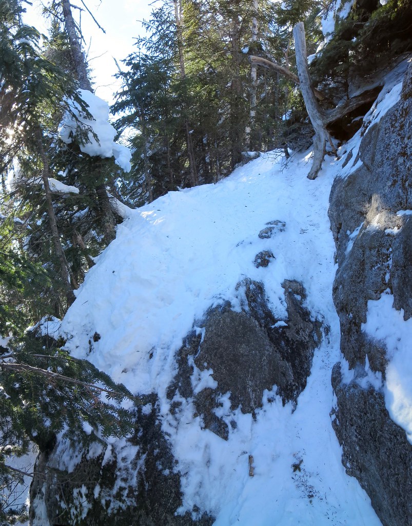 |
| The "Colvin Step". Ladder is barely visible. |
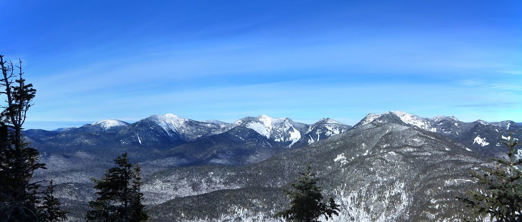 |
| Upper Great Range. |
Blake's summit is wooded but the views of Colvin during the ascent are worthwhile. I tagged the summit and looked around for anything new and notable. As expected, there was no evidence of traffic beyond Blake. With nothing else to see, I backtracked to the col. The descent was fast and fun. Many folks love butt-sliding but my favorite is slip-sliding while wearing Trail Crampons ("boot-skiing"). I was back in a flash (12 minutes).
I collected my pack and began the slog up Colvin. My pack felt unusually heavy and it took me 35 minutes to ascend Colvin. I wanted to attribute the experience to a low-mo day but I knew the real reason. Gluttony and sloth best describe my Christmas holidays and I was reaping what I sowed.
I thought back to March 2014 when I hiked Dial, Nippletop, Colvin, and Blake in 8h 35m. That was just not gonna happen today! Exercise, and hiking, got me into that kind of shape so I vowed to start exercising again (don't we all).
Colvin's summit was warm and sunny; I stripped down to a baselayer. As for my hands, they felt like they had been in a steam bath all day. My fingertips became chilled twice but had rewarmed very quickly. The experiment with the vinyl gloves was a success and the only downside was pruney-white hands. With no significant elevation gain remaining, I looked forward to a quick descent on smooth snow. Despite falling twice (backwards and forwards), it was a 'fun ride' to the Elk Pass junction. I continued to the Fish Hawk Cliffs junction where I turned west.
The view from Fish Hawk Cliffs was a delight but the real treat was hearing the booming noises produced by the ice on Lower Ausable Lake. Warmed by the sun, the expanding ice produced deep bass tones. The cliff walls served to amplify and enrich the sounds. I wondered if the phenomena also produced infrasound. I heard a boom approximately every 15 to 30 seconds. I tried to record the sounds (via video) but the result was unimpressive. The first 15 seconds of this video (from Sweden) is representative of what I heard:
Here's a more complex example recorded at a lake in Yosemite and this blog has more examples, taken in air and water, of ice noises.
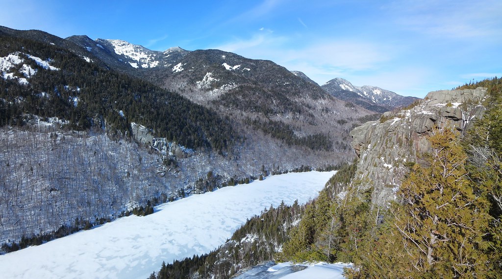 |
| Indian Head watches over Lower Ausable Lake. |
I'd had my fill of the views and began the steep but switch-backed descent to the Lake Road. The trail passes a stretch of vertical rock which, given the right conditions, develops impressive ice formations. Indeed, seeping water had coated the rock-face and formed seven "frozen waterfalls". The wall is undercut so the base of the formations became pillars of ice.
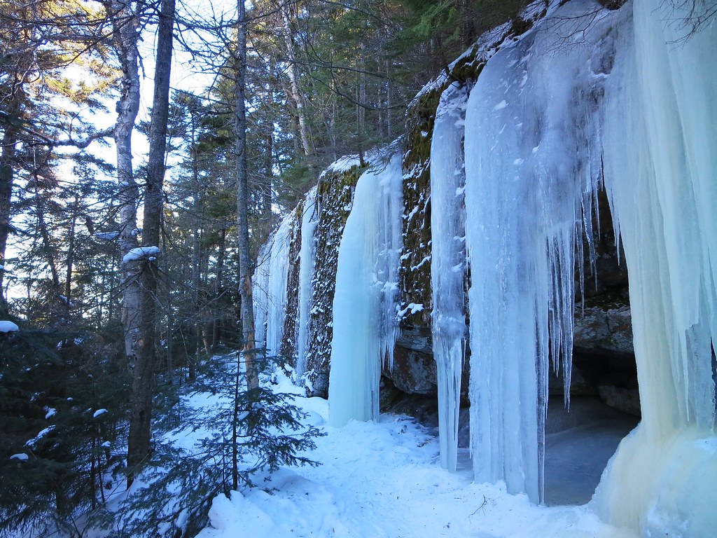 |
| Ice pillars. |
Along the way I passed a lone hiker, whose pack was emblazoned with many patches, and a young couple returning from Sawteeth. I signed out and entered the wrong time. A minute up the road I realized my mistake and returned to correct it. Awkward!
I returned to my car and changed into clean clothes. While stowing my gear the fellow from Rochester returned. He reported he had ascended Sawteeth via the Scenic trail and was unaware few people use it in winter. I laughed and said he probably now knows why it sees so little use. He concurred its steepness was impressive and it was far more rugged than the "highway" that is the Weld trail. I wished him a safe trip home and we parted company.
The hike had expunged the low-mo and left me feeling re-invigorated. I couldn't ask for more.
Photos
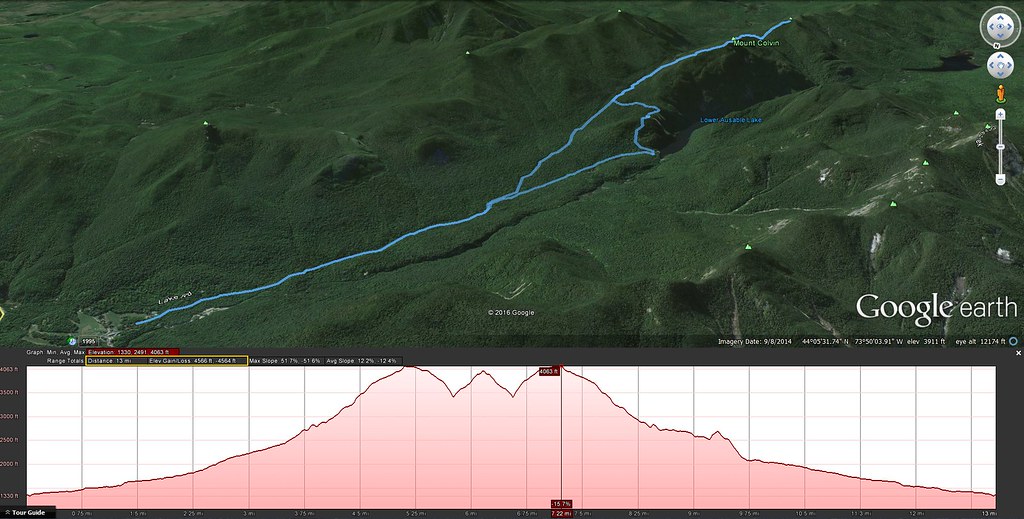
See all photos.Stats
Distance: 13 milesAscent: 4565 feet
Total time: 6h 35m
Moving time: 6h 03m
Scenery appreciation time: 32m
07:32 AMR Trail-head
08:20 Gill Brook Cutoff
08:33 Gill Brook
08:53 Fish Hawk junction
09:16 Elk Pass junction
10:04 Colvin arrival
10:18 Colvin departure
10:38 col
11:03 Blake arrival
11:05 Blake departure
11:17 col
11:52 Colvin arrival
11:53 Colvin departure
12:15 Elk pass junction
12:28 Fish Hawk junction
12:39 Fish Hawk Cliff arrival
12:54 Fish Hawk Cliff departure
01:04 Indian Head arrival
01:06 Indian Head departure
01:22 Lake Road
01:33 Gill Brook Cutoff
02:07 AMR Trail-head