Saturday, March 5, 2016

Tabletop and Phelps. 2016-03-05


I spent a beautiful Saturday morning hiking to Tabletop and Phelps from ADK Loj. A shout-out to the forum members I met "Hi KV_Streamer, DLhiker, and gb-mtns!" I had to leave home extra early to make it happen but it was worth it.

My wife needed the car back by 4:00 PM so after scanning March's Grid list, I chose Tabletop and Phelps for the day's peaks. I budgeted 12 hours for the outing based on 5 hours for driving, 6 hours for hiking, plus a 1 hour margin for error. I'd need to leave at 4:00 AM so that meant getting out of the sack at 3:30 AM.

On Friday evening, to save time the following morning, I packed the car with gear and set out everything I'd need to prepare breakfast. My standard winter-hiking brekkie consists of banana, cereal with skim milk, two poached eggs, three slices of buttered toast, and a mug of tea. My short-order cook skills are improving and I managed to wash, dress, cook, eat, check weather and news, tidy the kitchen, brush teeth, and kiss my wife goodbye in 35 minutes. Five minutes behind schedule but the margin would absorb it.

The pre-dawn sky was decorated a new moon, a ghostly fingernail low in the eastern sky. Nautical twilight arrived around 5:20 AM and backlit the Green Mountains with an indigo glow. I arrived at the ADK Loj shortly before sunrise and saw several hikers heading for the trail-register. A sure sign of a busy day to come. I crawled over the console into the passenger seat and began preparing for the hike.

I signed in at 6:37 AM. The sky was clear blue and it was a brisk -17 C / 1 F. The trail was frozen ground skimmed with ice. My Trail Crampons immediately began playing "Ode to a Rock Crusher".

Right on cue, I began to sweat and, copying last week's success, I stripped down to a single baselayer. It was still nippy and my arms and belly felt on fire. Nevertheless, it successfully reduced the sweating. I marveled at the hikers I passed who wore insulated jackets and pants.

I opted for the 'squirrel' crossing and it was in fine shape; Marcy Brook was frozen over. I emerged on the Truck Road and paused at the dam to check my watch. My Loj-to-Dam time is a measure of my pace and health. Forty minutes is average and I just did 37 so all systems were nominal. Onwards and upwards!

The paucity of snow is quite remarkable. There's only about an inch covering the woods flanking the Van Hoevenberg trail. It doesn't increase appreciably until one passes the junction to Phelps Mountain. In contrast, it feels like true winter at Indian Falls. Marcy Brook is invisible under the snow. Beyond Indian Falls, the trail definitely looks skier-friendly. I paused to view the MacIntyre range and then backtracked to the Tabletop junction.

Colden and the Macs from Indian Falls.
It was the first time I followed the re-routed section. They've done a fine job of putting distance between itself and the ski trail. About 200 yards from the junction, I stashed my snowshoes under a snowy spruce bough. It was near a bend in the trail and I scribbled a few lines in the snow to mark the spot.

The trail to Tabletop was in tip-top shape. Normally it's a muddy gutter but on Saturday it was a smooth highway of snow and ice. I passed the new summit sign and proceeded to the eastern lookout where I was greeted by Basin, Haystack and Marcy. Seeing all there was to see, I made a speedy descent and had so much fun that I passed my hidden snowshoes. Everything about the topography indicated I had missed the cache; the land had leveled out and the tree boughs were no longer at ground level. I dumped my pack and walked back about 100 yards to retrieve my snowshoes.

Looking south to Marcy.
March 5th happened to be the day of the ADKHighpeaks Winter Gathering. An annual event involving fund-raising, hiking, eating, drinking, and socializing, it also attempts to place at least one person on each of the forty-six ADK46er summits. I knew who had registered to climb Tabletop and Phelps so I asked a group of ascending hikers if anyone was "KV_Streamer". They pointed to her and we shook hands and introduced ourselves. After a brief summary of the trail conditions to Tabletop, I wished them well and continued my descent.

I arrived at the Phelps Mtn. junction at around 9:30 AM and realized I was likely to finish well within the allotted 6 hours. I started up the trail and paused at a flat icy section where I hid my snowshoes behind a fallen tree. Unlike Tabletop, Phelps' trail had far more exposed ice. Forty-five minutes later I stood on Phelps' sunny but crowded summit. Amongst the dozen or so hikers was "DLhiker" who I had the pleasure to meet for the first time.

I spent about ten minutes on the summit, mostly soaking up the views. It was pleasantly warm in the sunshine and seemed like a good time to finally eat something. After downing a Clif Trail Mix bar, DLhiker asked it I could take a photo of his group. Operating the smartphone's touchscreen required me to remove my hand from my vapor-barrier glove. It led to a brief explanation of how dirt-cheap "food preparation gloves" keep my cold-sensitive hands warm and my mitts dry.

Busy day on Phelps.
I wished everyone a great hike and proceeded down the trail. The Trail Crampons did an admirable job and there was only one section where I had to proceed cautiously. Along the way I met several other hikers including "gb-mtns" and his wife who were registered for Phelps. Hi again folks!

During my descent, I met two pairs of hikers who asked if they were close to the summit. By the terrain's appearance, I knew I was very close to the trail-junction. The entire ascent still lay ahead of them. I explained there was no way to sugar-coat it but they still had a significant climb ahead of them. I wished them well and proceeded to retrieve my hidden snowshoes.

Upon arriving at the Phelps junction, the day's major ascents were done. All that remained was to return to the Loj. In the morning, it had taken me an hour, to get from the Loj to the Phelps junction, so I endeavoured to at least match that time.

Unlike last week's "low energy" situation, mind and body were now in sync and I managed to shave 15 minutes off the hour. Total time was just under 5 hours but most importantly I felt better than at the end of last week's hike.

Photos

See all photos.

Statistics

Time: 4h 53m
Distance: 12 miles
Ascent: 4200 feet

Saturday, February 27, 2016

Colvin and Blake. 2016-02-27

I had set out to add four peaks to my February Grid but the ol' bod suggested I keep it real. Something was amiss and my willing spirit had to battle reluctant flesh all morning long. After C&B, I turned towards Elk Pass and then my spirit capitulated as well; the whole package pivoted back to the Lake Road. There would be no 8.5 hour tour of CBND today. Nevertheless it still made for a better day than sitting at home. Six hours, gate-to-gate, plus I got to meet three new people. Hello Sporty Spice, Little Miss Brave, and sati!

I left home at 5:00 AM and was treated to a beautiful sunrise over the Green Mountains. Some folks from MOAC planned a moonlit walk up the auto-road to Whiteface's summit to watch sunrise. I think they got their money's worth!

I rolled into the Ausable Club's parking area shortly after 7:00 AM. It was a crisp morning (-11 C/ 12 F) under a clear blue sky. I signed it at 7:37 AM and optimistically indicated Colvin, Blake, Nippletop and Dial.

The Lake Road was paved in ice. I stopped at the Leach trail junction to put on Trail Crampons. A group of three, headed for Dial and Nippletop, did the same. Sweating had begun on cue and I stripped down a single baselayer.

The ice was very hard. My spikes filled the air with the din of a rock-crusher. No one would have a problem sneaking up behind me because I could hardly hear myself think.

The recent heavy rain had caused brooks and rivers to overflow their banks. I passed a section of road that looked like a skating rink. Later, on the trail, I'd see "blowouts" where water emerged from the icy surface and deposited a long stream of frozen earth.


Trail "blowout".
I turned into the woods at the Gill Brook Cutoff and the snowcrete effectively silenced the rock-crushers. Two of the three campsites along Gill Brook were occupied. I could hear stirring from the cluster of tents at the second site. I passed a group of four hikers taking pictures; I'd meet then again later.

I reached the Elk Pass junction and turned right to Colvin. The first icy patch was a little tricky in Trail Crampons but, fortunately, it proved to be the worst of the lot. Before ascending too far, I found a thick clump of firs and promptly deposited four pounds of ballast in the woods (I hid my snowshoes).

I felt something was "off" today. I didn't feel strong and had to keep adjusting my pace to avoid becoming winded. I thought my pace was at least as good as last month's trip yet I felt I was working harder. (Jan/Feb: 48m/42m)

Moments after arriving on Colvin, low clouds rushed in from the south and obscured the higher summits. It turned into a blustery snow squall with a biting wind and reduced visibility. I donned my hard-shell, took a long swig of water, stuffed my camera and a Clif bar into my pockets, then proceeded a few yards down the trail to hide my pack.

Snow squall passing through.
Unencumbered by paraphernalia, I felt light and agile. The wind-chill was noticeable and I battened down my hard-shell. For a moment I considered returning to retrieve overmitts but I figured a bit more effort would rewarm my hands (it did). I think I finally got the hang of the two ladders and can now descend facing forward like on a staircase. Practice makes perfect!

Once again, the ascent of Blake felt harder than it had in January despite the fact my time was the same (25m). I tagged the summit, wandered out into the snowy "clearing", discovered its views weren't any better, then returned to the col. The steep sections, now thoroughly paved in ice and snow, were a breeze to descend.

I returned to Colvin in about the same time I had in January (Jan/Feb: 35m/32m) but, even without a pack, it felt harder than it should have. I passed the four hikers I met earlier. When asked how were the views from Blake I sensed it was wry inquiry so I replied with a smile "Oh, you know, the usual."

I collected my pack, paused on Colvin for one last view, then down-climbed the Colvin Step. The crack is now filled with ice and snow thereby providing better footing for spikes. The ladder is not visible.

All clear on Nippletop.
About three-quarters of the way down, a hiker wearing crampons inquired if my Trail Crampons were adequate. She said I looked familiar and asked if "I was on the forum". The inquiry led to an exchange of real and forum names. Sporty Spice said she donned crampons at the first gnarly patch of ice but found they were overkill afterwards. I confirmed the first patch was the most challenging and the rest of route to Blake was achievable in Trail Crampons. We wished one another a great day and went our separate ways.

I retrieved my snowshoes and descended to the Elk Pass junction. After a bit of mental see-sawing, I tipped in favor of continuing to Nippletop. One small step at a time will get the job done. Less than five minutes into the decision, I stopped in my tracks. The muscles in my legs, normally stoic, grumbled. As sudden and unwelcome as the snow squall earlier, a gloomy mood clouded my mind. I decided this was definitely an off-day and it was best to end it on happy note. I turned around and began an easy-breezy descent to the Lake Road.

While downwind of the campsites, I caught a whiff of "humans". The cold clear air amplified the collective odor of campers. Nothing nasty but distinctively "not woodsy". I think "sleeping bag funk" would describe it best.

I remained on the Gill Brook trail to get the best view of the brook and its numerous icy cascades and pools. I greeted a pair of hikers and met Little Miss Brave and her companion Sati, friends of Crepuscular. They were heading to Nippletop and that led to a brief discussion of the day's trail conditions. They were using Trail Crampons and I said they probably wouldn't have too much difficulty ascending but the descent might require some care. I wished them well and we parted company.

I followed the "Scenic" option along Gill Brook and it led to the brook's flooded and frozen edge. There were an endless variety of natural ice sculptures. Several of the ice formations reminded me of the rippled pillars and mounds found deep in caves. The sky was blue and clear and I felt a touch of regret for cutting the trip short. Nevertheless, I knew it was for the better. I'd return on a day when body and mind worked as a team.

Flooding on Gill Brook trail.
The Lake Road remained as tough as boilerplate although the temperature was now a balmy -1 C/ 30 F. A half-hour's march brought me back to the AMR gate, six hours from departure. I only covered half of my intended itinerary but a wise man once said "Don't be greedy!"

Photos

See all photos.


Saturday, February 13, 2016

Cascade and Porter. 2016-02-13


The weather forecast for the weekend predicted bitterly cold summit temperatures with windchills dipping below -45 C (-50 F). I had not hiked in three weeks and was itching to stretch my legs. I picked Cascade and Porter because:
  1. I was pressed for time; I had to be back home by 5:45 PM.
  2. They were on my February Grid list.
  3. Cascade offered a bit of exposure to sample the arctic weather.
Saturday morning's commute was complicated by slippery roads in Quebec. The combination of an inch or two of overnight snowfall, bitter cold, strong crosswinds, and drifting snow made my pre-dawn drive less than leisurely. In contrast, I-87 was bone-dry and the surrounding fields and forests were devoid of snow.

I arrived at 8:05 AM and promptly began the ritual of preparing for hiking on a frigid winter's day. My car's thermometer indicated -22.5 C (-8.5 F). The forecast called for brisk winds and a cooling trend. It was an excellent opportunity to try a few new things with clothing and gear.

Although I've used a hydration system on all my winter hikes, I opted for an insulated bottle of water. Ultimately, I drank none of it! Nor did I eat anything. For some reason I felt neither thirst nor hunger.

I wore vapor-barrier (VB) gloves to keep my mittens dry. It worked very well because my cold-sensitive hands didn't become rigid claws in the bitter cold.

My experiment with VB socks was less successful. To prevent the plastic bags from riding down my feet, and scrunching up around my toes, I taped them in place. At the end of the hike, I discovered the bags hadn't slipped but my toes punched through and created gaping holes. At least it explained why my toes felt nippy while standing around.

Last but not least was my cold-sensitive nose. I have a neoprene facemask but it's overkill below treeline. In a pinch, I cut holes in a fleece stuff sack and, ta-dah, made an old-fashioned "ski mask". In practice, the garish green mask made me look like a luchador (just call me "Cabeza Verde"). It needs improvement because the end of my schnozz developed a touch of frostnip.

I signed in at 8:30 AM and stopped a mere ten minutes later to remove my mid-layer. I was now down to a thin baselayer and a wind-shirt. Nevertheless, true to form, I continued to perspire heavily. It condensed and froze as "snow" on the surface of the highly-breathable wind-shirt. Maybe I need a VB shirt?

I opted to use Trail Crampons and left my snowshoes in the car. The paucity of snow this winter merits calling the situation a "drought". There's far less than eight inches of snow at the start and maybe only that much above 3900 feet. The trail had a thin layer of snow over a base of ice. The initial stretch had many rocks poking through the base.

Around 3300 feet I sensed a drop in temperature and my nose felt a bit stiff. This is a warning sign that my schnozz is at risk of frostbite. I paused to don my Cabeza Verde mask. At that moment, I met two descending hikers also wearing masks. I addressed them as "Mexican wrestlers" and got a chuckle. They reported Cascade's summit was bitterly cold and they spent only enough time to get photos.

When I put on my luchador mask, I also removed my eyeglasses. Despite an application of Cat Crap, they eventually fogged to the point of opaqueness. Fortunately, I can see well enough to hike without them, especially on a smooth snowy trail on a bright sunny day.

The trail to Porter was windswept and untracked. The trail conditions were perfect for spikes. On Porter's summit, my camera balked at the cold and reported "Charge battery". I jammed a smidgen of Kleenex between the battery and its door to exert more pressure and create better electrical contact. That worked to allow for a few photos but then it gave me the "Battery Aziz" message again. My chest pocket was obviously too cold so I stuffed the camera into my pants pocket and dashed back to the trail junction.

Luchador "Cabeza Verde" visits Porter.
Cascade from Porter.
Along the way I took the side-trail to the lookout over Railroad Notch. It was my eight visit to Porter but the first time I've bothered to pause at this lookout! The veil of clouds tried but failed to obscure the frozen ponds in Little Meadows. It might have made for a good photo if my camera battery wasn't in cryo-sleep.

I zipped past the trail-junction and stopped at the base of Cascade's bare summit. It was time to put on my spacesuit. While extracting it from my pack, two hikers passed me. One was accompanied by his dog. The pooch wore booties and didn't seem to mind the cold. The second hiker paused to inquire if I'd mind taking his photo when I arrived on the summit. I hesitated then agreed. The source of my hesitation would soon reveal itself.

I donned a pair of insulated pants. The side-zippers spare you the inconvenience of removing footwear. However, when fully unzipped, the spatchcocked pants becomes a "clothing puzzle". It takes more than one attempt before this unfamiliar item goes on correctly! My windshirt was damp so I stripped it off and replaced it with the mid-layer I had removed earlier. Knowing it would be board-stiff upon my return, I rolled it up and stuffed it into my pack. Love nor money would get me back into that frozen jacket.

For the first time ever, I wore my fully-baffled down jacket. It was like wearing a sleeping bag. Its hood muffled external sounds like a pillow wrapped around one's head. Goggles and a neoprene facemask completed the astronaut costume. I left my poles and pack and strolled up to the summit.

The hiker and his dog were already descending. The photo-requesting hiker was seated in the lee of a rock. He wore half-gloves and his exposed, cherry-red fingers held a smartphone. I thought this might happen. There was no way I was going to bare flesh to operate a touchscreen. I looked at him and shouted through my facemask "You want me to expose my fingers in this cold?" He paused, looked at his own suffering hands, then apologized and wished me well. I didn't feel good about it but I was unwilling to extract a damp hand out of a plastic glove and expose it to a windchill of -40 F. He'd have to settle for a selfie.

Astronaut on Cascade.
Aside from the stinging wind that nipped at my nostrils, and seeped in through the filtered edges of my goggles, I was immune to the cold. A gust or two would occasionally jostle me but that was part of the experience I sought. I got my money's worth and I was happy.

The wind tested my defenses and found a breach near my left temple. I adjusted my hood and facemask to seal the draughts. I thought about what I'd do differently if I had to hike for an hour or more in these conditions. Knowing how I perspire during exertion, there's no way I could continue to wear this duvet of a jacket. I'd have to wear a lighter synthetic jacket that I normally use in winter.

The nipping at my nostrils fed my paranoia about frostbite. Perhaps I need a facemask with a "walrus snout" to provide better protection (Outdoor Research's Gorilla Balaclava). Anyway, it was all academic because these conditions usually keep me below treeline.

-25 C/-13F + 35 mph wind gusts = Brrr!
I spent at least 15 minutes ambling around the summit, appreciating the arctic conditions and whatever scenery materialized through the clouds. Big Slide's silhouette was recognizable in the mist but not much else was visible beyond it. My camera had returned to life long enough to take a few photos before the cold put back into deep sleep.

Howard was leading a MOAC trip on nearby Pitchoff so I took a few photos of it in hope of spotting his group. After I had seen all there was to see, I began to make my way down to my pack. Along the way I met a lone hiker and asked her if she could take my photo. I assured her it had a shutter button! She tried but was unable because the camera was still too cold.

As expected, separated from my warmth, my windshirt had turned into a frozen ball. I removed my down jacket and replaced it with a hardshell. I stuffed it, the pants, goggles, and facemask into my pack, shouldered it, and began a fast descent to the trail-head. I probably should've put on my luchador mask but I felt my pace would generate enough heat. I was mistaken.

I passed at least six groups of hikers ranging from 4 to 12 people in size. One of the hikers, I'll assume she was a group leader, commented that I had developed a white spot on my nose about a centimeter in size. I stopped immediately, thanked her for bringing it to my attention, and explained "It has a habit of doing that!"  I donned my neoprene facemask because it covers my nose better than my homemade ski-mask. With only my eyes visble between my black hat and facemask, I looked like a ninja. If you were one of the 50+ hikers ascending Cascade on Saturday, I was the masked man careening down the trail.

In addition to seeing many hikers, I also saw two enormous piles of dog feces. I don't care the two dogs I saw were unleashed. That's between the owners and rangers they meet. I do care about the "brown klister" they leave on the trail. A misstep might collect an unwanted memento of the trip. All I ask is that dog owners clean up after their pets; at the very least, kick that $hit into the woods.

I signed out at 11:40 AM and added a "Clean up after your dog!" note in the margin of the logbook. It's likely to go unheeded but at least the message is out; dog poo on the untrail is unappreciated. I took a photo of the logbook page (as is my custom now) and counted ten groups had signed in, representing over 55 people. Clearly the bitter cold hadn't diminished the lure of hiking Cascade.

Stay frosty!
I changed into dry clothes, bagged what I wore on the trail, spread out damp jackets to dry in the car, stowed my gear, and called my wife to report I was safe and sound. I made one last trip to the trunk when someone addressed me. I looked up and didn't recognize the masked individual but he spoke like he knew me. I finally recognized his voice and it was John (MtnManJohn). I greeted him and we discussed the trail conditions. He was also heading up for a "gear testing" hike in the arctic conditions. Like a tag team match, one luchador tagged the other and "Hombre de la montaƱa" was off into the ring!

Photos

See all photos.

Statistics

Time: 3h 10m
Distance: 5.7 miles
Ascent: 2350 feet

Sunday, January 24, 2016

Colvin and Blake. 2016-01-24

Something for your "low-mo" day, sir?

Sunday's weather was predicted to be excellent and I wanted to be out in the mountains. However, it was a "low-motivation" day; nothing seemed to pique my interest. From past experience, low-mo is instantly cured the moment my feet touch the trail. The biggest hurdle to overcome is getting from home to trail-head.

January's Grid list offered many challenging destinations but I wasn't in the mood for them. I wanted a sub 8 hour hike so I chose Colvin and Blake with a side-order of Fish Hawk Cliffs and a glass of Indian Head.

I left my home at 5:00 AM. The US Customs and Border Protection officer subjected me to an unusually long list of questions. The dozen or so inquiries ranged from the usual, such as destination and purpose of visit, and then probed deeper to frequency of entry, employment status, vehicle's owner, and wife's occupation. I felt his question about why my wife had not joined me was a little over the top. Nevertheless, I responded politely and was granted entry.

Sunrise was an hour away and the night sky treated me to the full moon low in the west and five planets in the east (Mercury, Venus, Saturn, Mars, and Jupiter). However, I only identified four planets and missed Mercury.

I made good time and rolled into the St-Huberts parking area at 7:00 AM. I spent about fifteen minutes prepping for the day. I'd be trying something different to keep my hands warm. Normally I use a combination of fleece mitts, liner gloves, and chemical hand-warmers. Nevertheless, I'm still prone to developing painfully cold fingers especially after extracting my gloved hands to perform a task (like operate a camera). Today, my first line of defense would be a vapor-barrier in the form of a pair of vinyl gloves. I had tried this trick using nitrile gloves but they were too snug and my fingers became cold (not the material's fault but the fit).

While collecting my gear from the trunk, I met a fellow from Rochester, who planned to hike Sawteeth. He was the first to sign the trail-register and I was the second. By day's end, eleven other groups signed in with most heading to Sawteeth, Dial and Nippletop, or Gothics. I was the only one to register for Colvin and Blake.

I left the trail-head at 7:32 AM. The temperature was a cool -15 C (4 F) and the sky was clear. As expected, my motivation was restored the moment I began my stroll along the Lake Road. I tried to catch up with the Rochesterian but didn't see him again until the end of the day.

The road was hard-packed and, if one steered clear of the icy patches, easily negotiated in bare-boots. I considered heading directly to Indian Head but chose the "trade route" via the Gill Brook Cutoff. I arrived at the junction at 8:20 AM and set off on the trail's firmly-packed snow.

Saturday's hikers had groomed the trail which made for easy walking. I paused at the Elk Pass junction to don my snowshoes. Frankly, the trail-bed was dentproof but the snowshoe's Televators relieved calf-strain so why not put them to good use.

The trail was effectively paved from junction to summit. The snowshoe's aggressive traction helped on sections of trail that had been polished smooth by butt-sliders. The facetiously named "Colvin Step" had just enough snow to simplify its ascent. Its recently installed ladder was buried in snow and only a portion of one rung was visible.

The "Colvin Step". Ladder is barely visible.
I took a short break on Colvin's summit to soak up the views and have a snack. I had bought a box of "Clif Organic Trail Mix" bars (on sale at Costco) and found them to be tastier than the regular Clif bars. Whereas frozen Clif bars are tough and difficult to eat, these snap easily without fear of breaking teeth. A few photos and four hundred calories later, I headed to Blake.

Upper Great Range.
Shortly after leaving the summit, it became evident to me that snowshoes weren't the right tool for the job. I hid them under a snow-laden tree, put on Trail Crampons, and zipped southward to Blake. Unencumbered by duck feet, I was able to walk down the ladder face-forward, boot-ski the steeps, and arrive at the col's junction in a mere 20 minutes. I took a long swig from my hydration bag, hung my pack in a tree, and scooted up Blake. The steep icy stretches I had encountered in November were now buried under snow and made for easier travel.

Blake's summit is wooded but the views of Colvin during the ascent are worthwhile. I tagged the summit and looked around for anything new and notable. As expected, there was no evidence of traffic beyond Blake. With nothing else to see, I backtracked to the col. The descent was fast and fun. Many folks love butt-sliding but my favorite is slip-sliding while wearing Trail Crampons ("boot-skiing"). I was back in a flash (12 minutes).

I collected my pack and began the slog up Colvin. My pack felt unusually heavy and it took me 35 minutes to ascend Colvin. I wanted to attribute the experience to a low-mo day but I knew the real reason. Gluttony and sloth best describe my Christmas holidays and I was reaping what I sowed.

I thought back to March 2014 when I hiked Dial, Nippletop, Colvin, and Blake in 8h 35m. That was just not gonna happen today! Exercise, and hiking, got me into that kind of shape so I vowed to start exercising again (don't we all).

Colvin's summit was warm and sunny; I stripped down to a baselayer. As for my hands, they felt like they had been in a steam bath all day. My fingertips became chilled twice but had rewarmed very quickly. The experiment with the vinyl gloves was a success and the only downside was pruney-white hands. With no significant elevation gain remaining, I looked forward to a quick descent on smooth snow. Despite falling twice (backwards and forwards), it was a 'fun ride' to the Elk Pass junction. I continued to the Fish Hawk Cliffs junction where I turned west.

The view from Fish Hawk Cliffs was a delight but the real treat was hearing the booming noises produced by the ice on Lower Ausable Lake. Warmed by the sun, the expanding ice produced deep bass tones. The cliff walls served to amplify and enrich the sounds. I wondered if the phenomena also produced infrasound. I heard a boom approximately every 15 to 30 seconds. I tried to record the sounds (via video) but the result was unimpressive. The first 15 seconds of this video (from Sweden) is representative of what I heard:


Here's a more complex example recorded at a lake in Yosemite and this blog has more examples, taken in air and water, of ice noises.

Indian Head watches over Lower Ausable Lake.
After the novelty of lake noises wore off, I moved on to Indian Head to get a slightly different perspective of the same scenery. I recalled the ascent to Indian Head was short but seriously steep and my recollection was correct. Far below me, I could see two figures walking across the dam. Later I learned a couple had registered to hike Indian Head and Rainbow Falls so it could've been them.

I'd had my fill of the views and began the steep but switch-backed descent to the Lake Road. The trail passes a stretch of vertical rock which, given the right conditions, develops impressive ice formations. Indeed, seeping water had coated the rock-face and formed seven "frozen waterfalls". The wall is undercut so the base of the formations became pillars of ice.

Ice pillars.
I emerged on the Lake Road and paused to stow my Trail Crampons. I set out to stride/jog the remaining 3.3 miles to the trail-register. As always, I welcomed the opportunity the Lake Road provides to slip my mind into neutral and stretch my legs with a long and steady stride. I wished I had not given up running because where I tried to jog reminded me how quickly one goes to seed! Nonetheless, I set a personal best of 45 minutes.

Along the way I passed a lone hiker, whose pack was emblazoned with many patches, and a young couple returning from Sawteeth. I signed out and entered the wrong time. A minute up the road I realized my mistake and returned to correct it. Awkward!

I returned to my car and changed into clean clothes. While stowing my gear the fellow from Rochester returned. He reported he had ascended Sawteeth via the Scenic trail and was unaware few people use it in winter. I laughed and said he probably now knows why it sees so little use. He concurred its steepness was impressive and it was far more rugged than the "highway" that is the Weld trail. I wished him a safe trip home and we parted company.

The hike had expunged the low-mo and left me feeling re-invigorated. I couldn't ask for more.

Photos

See all photos.

Stats

Distance: 13 miles
Ascent: 4565 feet
Total time: 6h 35m
Moving time: 6h 03m
Scenery appreciation time: 32m

07:32 AMR Trail-head
08:20 Gill Brook Cutoff
08:33 Gill Brook
08:53 Fish Hawk junction
09:16 Elk Pass junction
10:04 Colvin arrival
10:18 Colvin departure
10:38 col
11:03 Blake arrival
11:05 Blake departure
11:17 col
11:52 Colvin arrival
11:53 Colvin departure
12:15 Elk pass junction
12:28 Fish Hawk junction
12:39 Fish Hawk Cliff arrival
12:54 Fish Hawk Cliff departure
01:04 Indian Head arrival
01:06 Indian Head departure
01:22 Lake Road
01:33 Gill Brook Cutoff
02:07 AMR Trail-head


Sunday, December 20, 2015

Giant and RPR. 2015-12-20

On Sunday, I arrived at the AMR lot with a MOAC group. The first person I recognized was Crepuscular (Chris). He, Koda, and other friends were heading to Noonmark. Koda ignored me. What a remarkable difference from our previous encounter. I had been ascending Dix, for my first winter 46er finish, and met Chris who was returning from the summit where he had left me a winter 46er memento (thanks, I still have it). Koda was, to put it mildly, not pleased to see me. If you haven't figured it out, Koda is a German Shepherd and our first meeting showed his overly-protective side. Nowadays, he's a product of Chris's dog-rearing skills and made no fuss when I shook Chris's hand.

Although the MOAC group was bound for Colvin and Blake, the team leader graciously allowed me to do my own thing. When one of the group members, Vladimir, learned I was going to Giant and RPR, he asked to join me. I asked that he  get clearance from the team leader. With permission granted, we set off along the Roaring Brook trail.

My personal best for Giant and RPR is four hours in snowy, late-winter conditions. Today's effort was not competitive in nature and would break no records. The goal was to safely get up and down the icy trails and provide Vladimir ample time to enjoy his first trip to Rocky Peak Ridge (RPR).

A light snowfall the previous night had whitewashed the frozen ground and ice. I soldiered along in bare-boots until the second slip, on snow-obscured ice, signaled it may be prudent to add spikes. Now the game was reversed. Without traction, I had sought rock and avoided ice. Now armed with sharp points, I avoided rock, to prevent needless dulling, and searched for ice. Vladimir wore trail-worn Kahtoola Microspikes whereas my boots flashed the freshly sharpened teeth of Hillsound Trail Crampons. The day's journey would prove it wasn't a fair fight.

Roaring Brook flowed freely. Rather than rock-hopping the snow-covered rocks, we crossed by walking on the shallowest submerged rocks. It seemed safer to me than jumping on rocks and discovering a veneer of ice beneath their snowy blanket.

We made good progress until we reached the first of many ice flows. The ice had had ideal freeze-thaw conditions to grow over the span of weeks of mild weather. However, it was no longer yielding and Microspike-friendly. The cold morning air had made it bulletproof. Vladimir struggled to gain purchase with his spikes and lost confidence in their holding power. My Trail Crampons held securely but I was careful to plant them squarely and "flat-footed" wherever it was practical. The hardened ice slowed our ascent and I paused to allow Vladimir to creatively ascend the iciest sections. The ice softened later in the day and he was able to descend with greater confidence. Nevertheless, I imagine he will either sharpen or purchase new Microspikes after this trip.

I wished I had brought my thermometer because I was curious to know the temperature. It seemed colder than advertised because my fingers became uncomfortably cold. They have become prone to chilling to the point of causing stiffness and pain. I paused to add mitten-shells and hand-warmers. Vladimir seemed unaffected by the cold and, at least for a short while, wore no gloves or mitts. Perhaps it wasn't as cold as I thought but my hands tacitly disagreed.

About a hundred yards before the Roaring Brook trail meets the Zander Scott trail, a "false trail" joins it. I recounted an anecdote to Vladimir about how it looks like a proper trail in winter. It had caused us some confusion because one of our party used it for a butt-slide and failed to appear at the trail-junction. This morning, filled with fallen trees, no one could possibly mistake it for a trail.

At the RPR junction we met the first of a handful of hikers we would see all day. He was waiting for his partner to return from RPR. We pressed on and arrived at a steep pitch with a dangling, weather-beaten rope. My first instinct is to remove all "user-based trail-modifications". However, I temporarily left the rope in place just in case someone ahead of us had left it there for their return.

Giant's summit was shrouded in a cloud bank. It was my fourteenth visit, so it wasn't like I had never seen its views. The rolling fog added a touch of moodiness to the scene. We stayed only long enough for a snack and then my toes signaled it was time to either add a layer or get moving. We left at a brisk pace, eager to add RPR to Vladimir's growing list of ADK peaks.

My 14th visit to Giant and it's a foggy one.

Before beginning our descent into the col, I cautioned Vladimir it would be steep and icy. He confirmed his desire to proceed, with trail-worn spikes, and so we dove in. The "usual suspects" were iced over and didn't fail to challenge us. It seems all of them have developed obvious bypass routes except for the man-high ledge (above the junction with the spur-trail). However, hiker traffic and erosion have exposed so many tree roots that they form a natural ladder; this ledge isn't as tricky to scale as it was in the past.

The clouds had lifted and we arrived to sweeping views atop Rocky Peak Ridge. The westerly wind was nippy so we walked to RPR's eastern side and enjoyed our lunch in relative warmth. I pointed out Lake Marie-Louise to Vladimir and described the wonderful traverse from the New Russia trail-head. As always, the view east was like a siren-call to complete the traverse. Enticing but impractical considering it was unlikely we could hitch a ride back after dark.

Vladimir arrives on Rocky Peak Ridge.
Shortly after leaving the summit, we met a lone hiker who commented on the steep descent into the col. "Lot's of butt-sliding!" I saw plenty of evidence of "trail-sweeping" earlier in the day. I can't imagine sliding down icy slabs was the most comfortable method of descent. We wished him well and continued along until we met two more hikers, Charles and GeneviĆØve. I recognized Charles as a regular on Fousderando.com ("Charlie"). He's a man of the cloth and always seems to have a different attractive woman (or two) accompanying him on his hikes. There's a story I'd like to know more about.

He wondered out loud why was I not hiking in the Sawtooths with Neil? He enjoys ribbing Neil about his obsession with bushwhacking the Sawtooth mountains. I explained Neil was the "Mayor of the Sawtooths" therefore he needed to be close to his constituents. Little did we know that Neil was in the Sentinels that day.

Appreciating the view from one of Giant's eastern slides.
We made a short detour along the spur-trail to savor the view from the slide. The conditions were too dicey to ascend the slide, especially with Vladimir's dull Microspikes. We returned to the main trail, made quick work of the ledge, and ascended to the main trail without incident. Before reaching the junction, I encountered yet another rope which was not present during our descent. I left it be because it was probably installed by either Charles or the lone hiker.

Back at the weather-worn rope, I concluded whoever installed it was no longer on the mountain. I untied it, used it to belay Vladimir's descent, then stowed it in my pack. I was able to easily descend the pitch without the rope.

I had failed to manage my hydration system and the bite-valve was now frozen. Nothing I did let the water flow freely so I tucked the free end of the hose into my jacket so it would eventually defrost. This would have regrettable consequences a short while later.

We continued to the "Over bump/Around bump" junction where I chose "Over" and Vladimir chose "Around". We met a few minutes later, at the base of the bump. I proceeded to dismantle two user-built cairns and then noticed the cold discomfort of a wet pant leg. Cue the punch line to my favorite joke "Hey! You're Arnold Palmer!"

I opened my jacket and discovered the bite-valve and its winter-cover had fallen off. The hose had defrosted and, whenever the pack was compressed, allowed the water to flow out onto me. Phooey! I removed my pack and asked Vladimir to wait while I ascended the trail to find the valve. Its cover was turquoise-blue so it would be easy to spot.

I climbed all the way back to the base of the bump but could not find the valve. Perhaps it fell off above the bump but I felt it wasn't worth the extra time and effort. The search was equally fruitless during the descent. I had to tie back the hose several times because it always found a way to squirt water (on my back, head, pack, etc). It finally ceased to be a nuisance when the hose frozen again. I've used a hydration bag for two winter rounds of the 46 and never experienced this glitch. There really is a first time for everything.

At the Roaring Brook junction, we chose to extend our hike by descending the Zander Scott trail to Giant's Washbowl. We would turn north, pass the base of Giant's Nubble and close the loop at the Roaring Brook trail. It seemed like a nice way to return to our car without backtracking along the entire length of the Roaring Brook trail.

High above the Washbowl, at a point where the Zander Scott trail transitions from woods to open slabs, we met a small group of photographers preparing for sunset shots. The low-lying clouds in the west offered the possibility of either dramatic colors or an unceremonious extinguishment. For their efforts, I hope it was the former. As we closed in on the Washbowl, we met a group of hikers hustling upward. They were attempting to watch the sunset but I feel they may have arrived a little too late.

A snow-free December.
The Washbowl's surface was still and only its perimeter was frozen. I saw hikers on the eastern shore, at a designated campsite, and perhaps they were preparing their tent for the night. We continued past the Washbowl and it dawned on me that this might be my first time along this pretty stretch of trail.

The Nubble's western cliffs loomed above us as we ascended to the height-of-land. The ice was now largely absent so I removed my Trail Crampons. The descent to the Roaring Brook junction was though open woods and made challenging only by the occasional patch of slippery leaves.

We crossed Roaring Brook in the same manner as we had in the morning. The failing light made following the trail a little more challenging. Ten minutes from the trail-head, I capitulated and donned my headlamp. Vladimir soldiered on in the dark. With improved visibility, I zipped ahead and quickly signed us out at the trail-register. A three-quarter moon had risen and cast its cold light on the snowless trees.

We arrived at the car and were joined by the MOAC group a mere five minutes later. The group leader was surprised to learn we had taken as much time as their (longer) tour of Colvin, Blake, and Indianhead. There wasn't much to say about it beyond the fact we encountered many steep pitches with hard ice (notably in the morning) and dull Microspikes added to the challenge. The smiles all around indicated everyone had a great day in the mountains and that's the best measure of all.

Approximately 8.6 miles and 5070 feet.

Photos

See all photos.

Thursday, November 26, 2015

Sunday, November 8, 2015

Iron, Owl Head, and Green. 2015-11-08

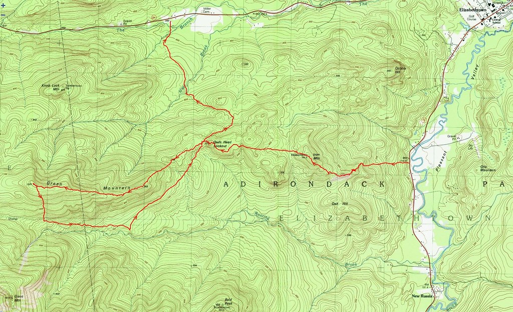
Standing at 3980 feet tall, Green is the 48th highest peak in the Adirondacks. It lies 1.5 miles north of the ever-popular Giant Mountain and no trails lead to its wooded summit. A very popular route to Green is from the south and involves about five miles of trail-walking, along the North Trail, followed by a steep, half-mile bushwhack ascent. Of the many ways to ascend Green, the one that appealed to me most was from the east. Departing the North Trail near Owl Head Lookout, one follows Green's ridge to its summit.

Neil suggested we up the ante and approach Green from the 
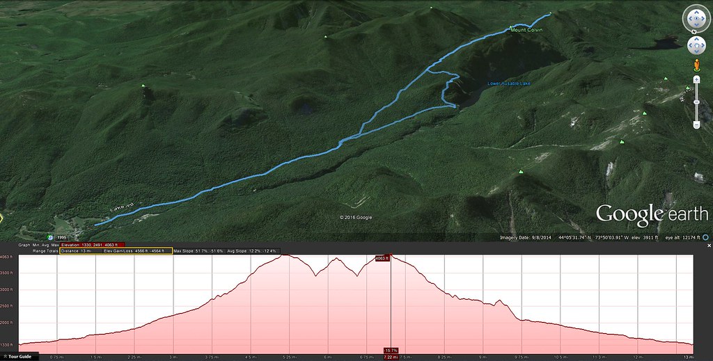
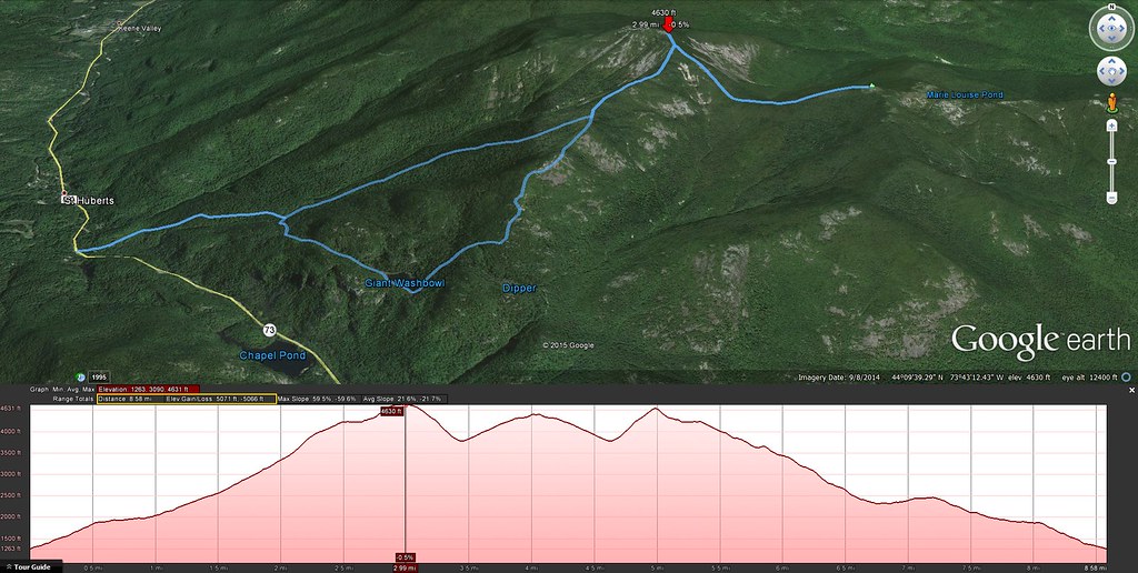
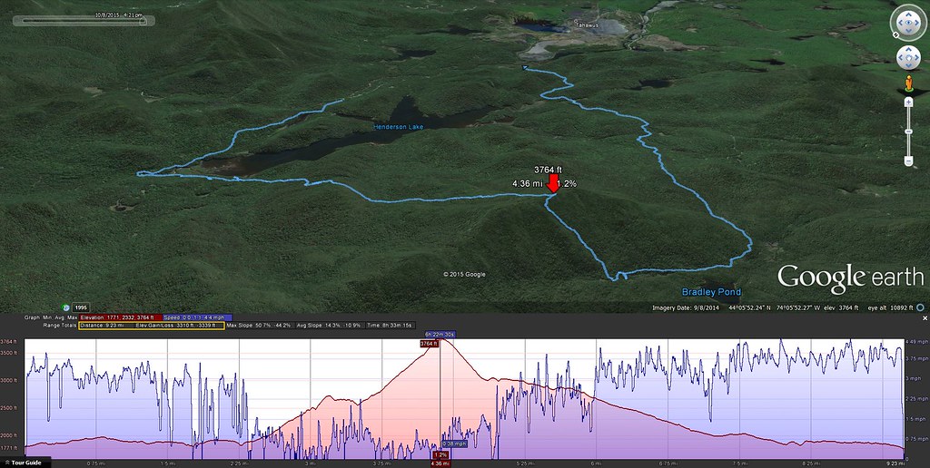
distant east. Our bushwhack route would start from highway 9 and proceed six miles over Iron Mountain, Owl Head Lookout, and along Green's ridge to its summit. Our return route would descend to the North Trail and follow it out to 9N. The proposed itinerary was more challenging than the "trade route". However, satellite imagery showed exposed outcrops and slides along the way so the payback would be scenic views. I was instantly sold on the idea.

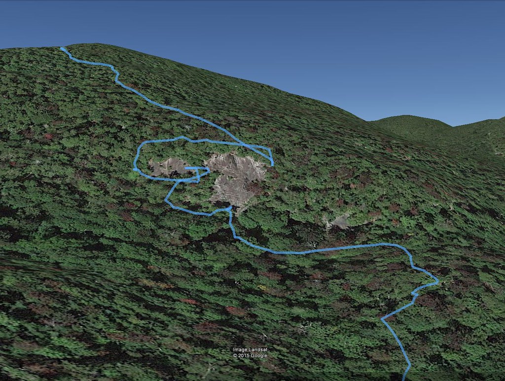
Our route from 9 to Iron, Owl Head, Green, and 9N.
Aerial view.
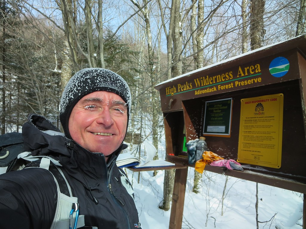
Expecting a long hike, we left Montreal at 5:00 AM and arrived at Tom Haskins' home two hours later. Many thanks to Tom for agreeing to shuttle us from one trail-head to the other. We parked my car at the Owl Head trail-head, on route 9N, and then Tom drove us to a pull-off on the west side of route 9 about 2 miles south of Elizabethtown. Based on information gleaned from the DEC's State Land Interactive Mapper (SLIM), we selected this point because it provides legal access to Iron Mountain. A great deal of the land lying east of Iron is private and only one section borders the highway.

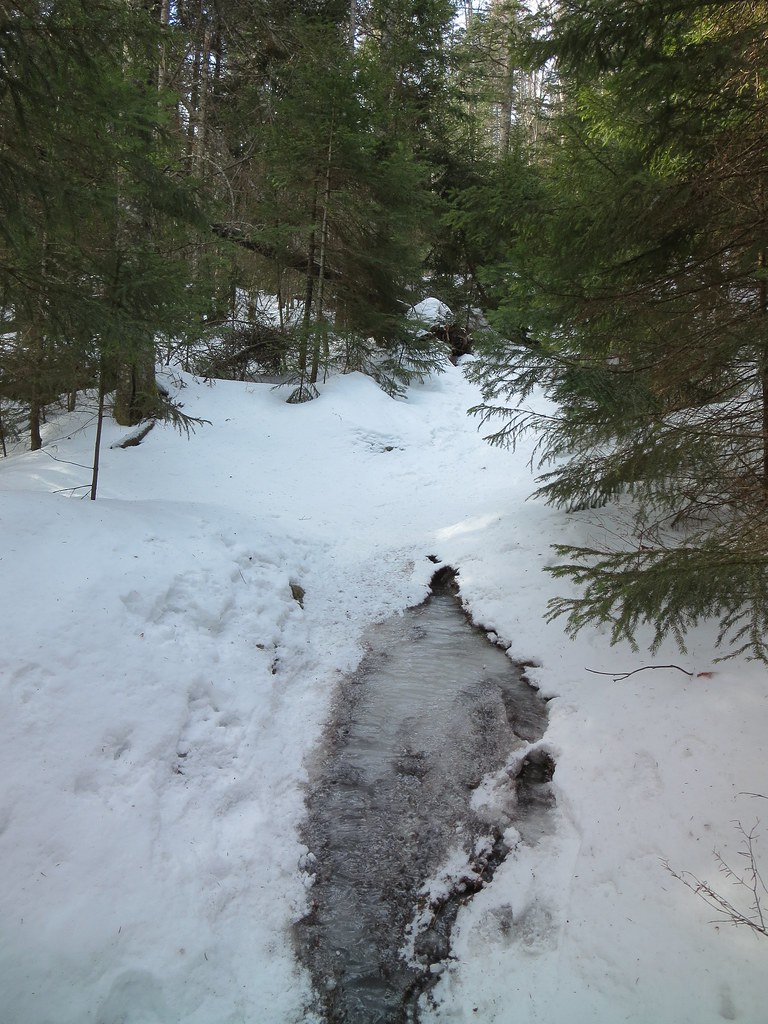
At 7:45 AM we bid Tom goodbye and immediately began ascending the steep embankment. After climbing about 150 feet, we were surprised to intersect an old road. We continued our ascent and crossed, re-crossed, and followed the road until it no longer coincided with our desired trajectory. The woods were surprisingly free of underbrush and, with a thick carpet of fallen leaves, made for very easy travel; there was no "bushwhacking" involved.


Hemlock Varnish Shelf (Ganoderma tsugae)
After a half-mile of park-like conditions, we breached a broad, grassy cliff and turned slightly southwest to join Iron's ridge. Mere feet below the northern side of the first knob, our progress was halted by a very broad wall of rock. We skirted it to the west and found a way to ascend it safely. In retrospect, an easier approach would be to curl around the southern end of the knob and avoid the wall entirely.
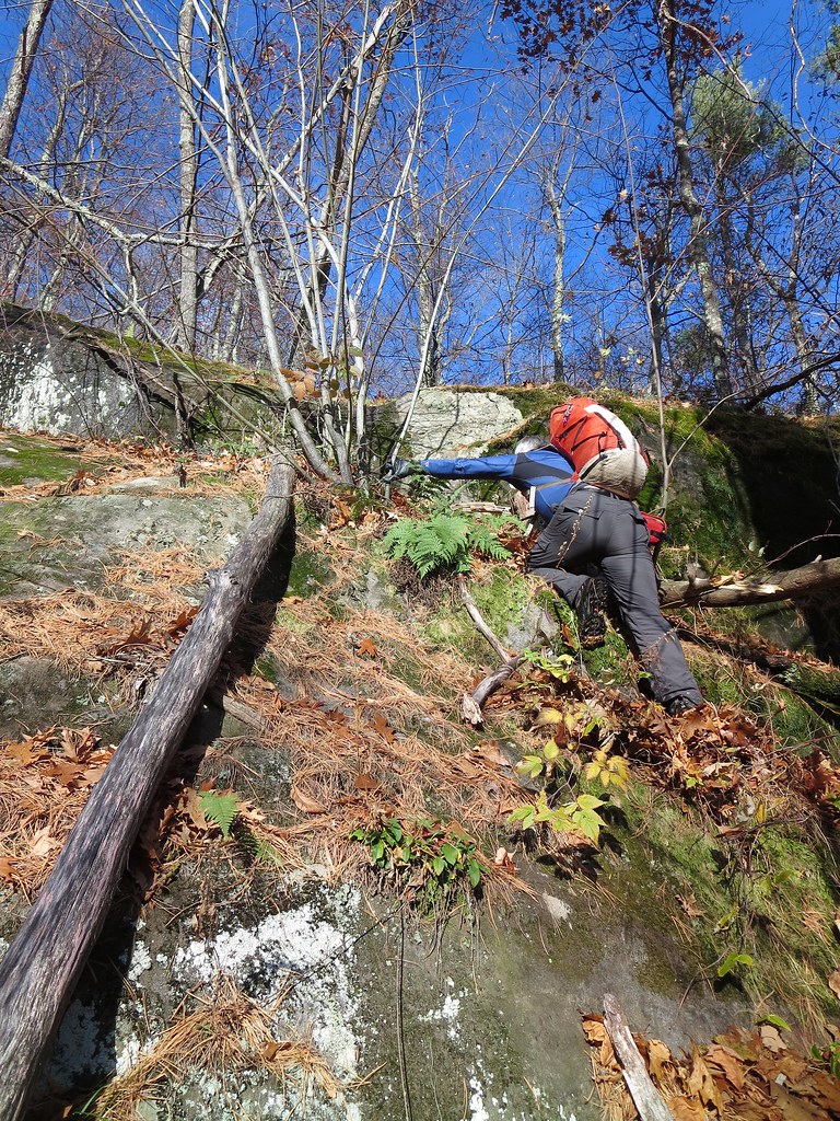
Working hard.
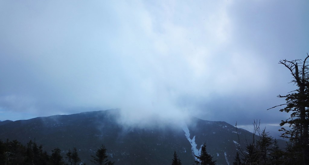
The open knob stands 1100 feet above route 9 and provides a commanding view of Pleasant Valley and nearby Elizabethtown. The mountains lying directly east were unfamiliar to me but I recognized the distant cloud-capped Green Mountains in Vermont. Later in the day, the clouds would lift and expose the distinctive silhouette of Camel's Hump.

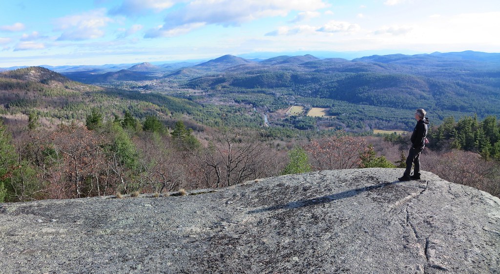
First clear view of Elizabethtown.
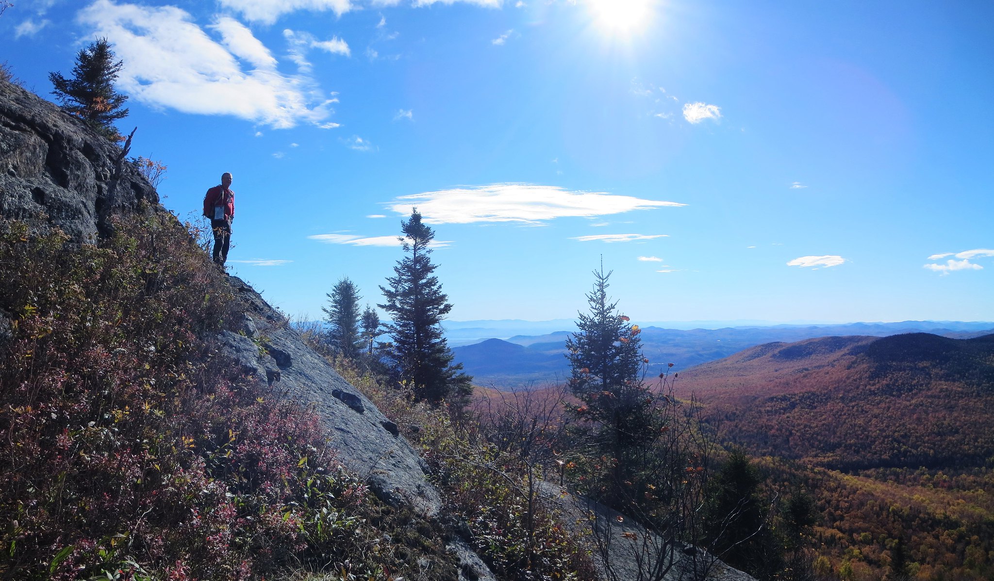
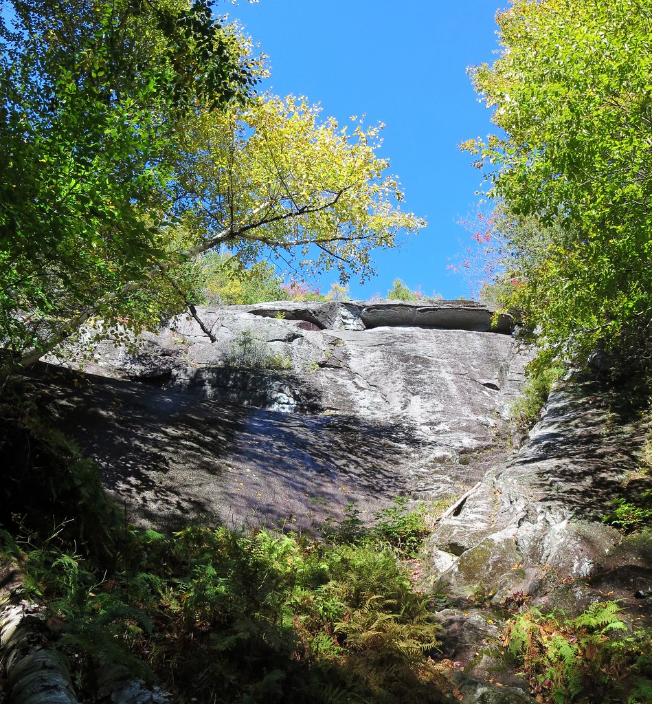
Navigation now consisted of "connect the dots" where the "dots" were visible rock outcrops. The next section of open-rock elicited a "Wow!" I had seen satellite images but they had not prepared me for the large slope of open rock. I blurted "What an amazing slab climb!" as I envisioned ascending it from the valley. an added bonus was discovering three eye-bolts in the rock. They were arranged in a triangle and probably secured a survey station in the past. There was a shallow hole at the center of the triangle but I could not find a "survey bolt". Was it the handiwork of Verplanck Colvin's first survey or something more recent?

Neil explores the bare slope.
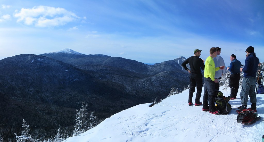
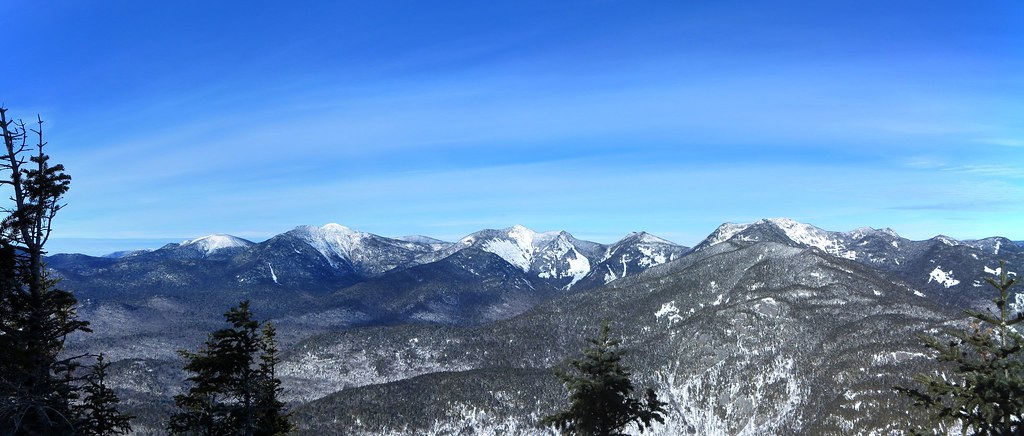
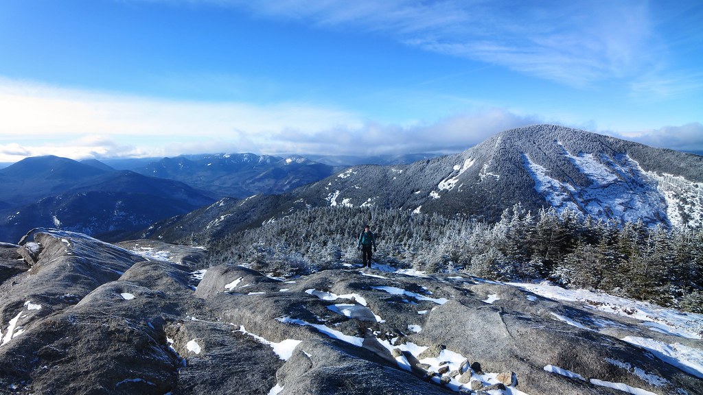
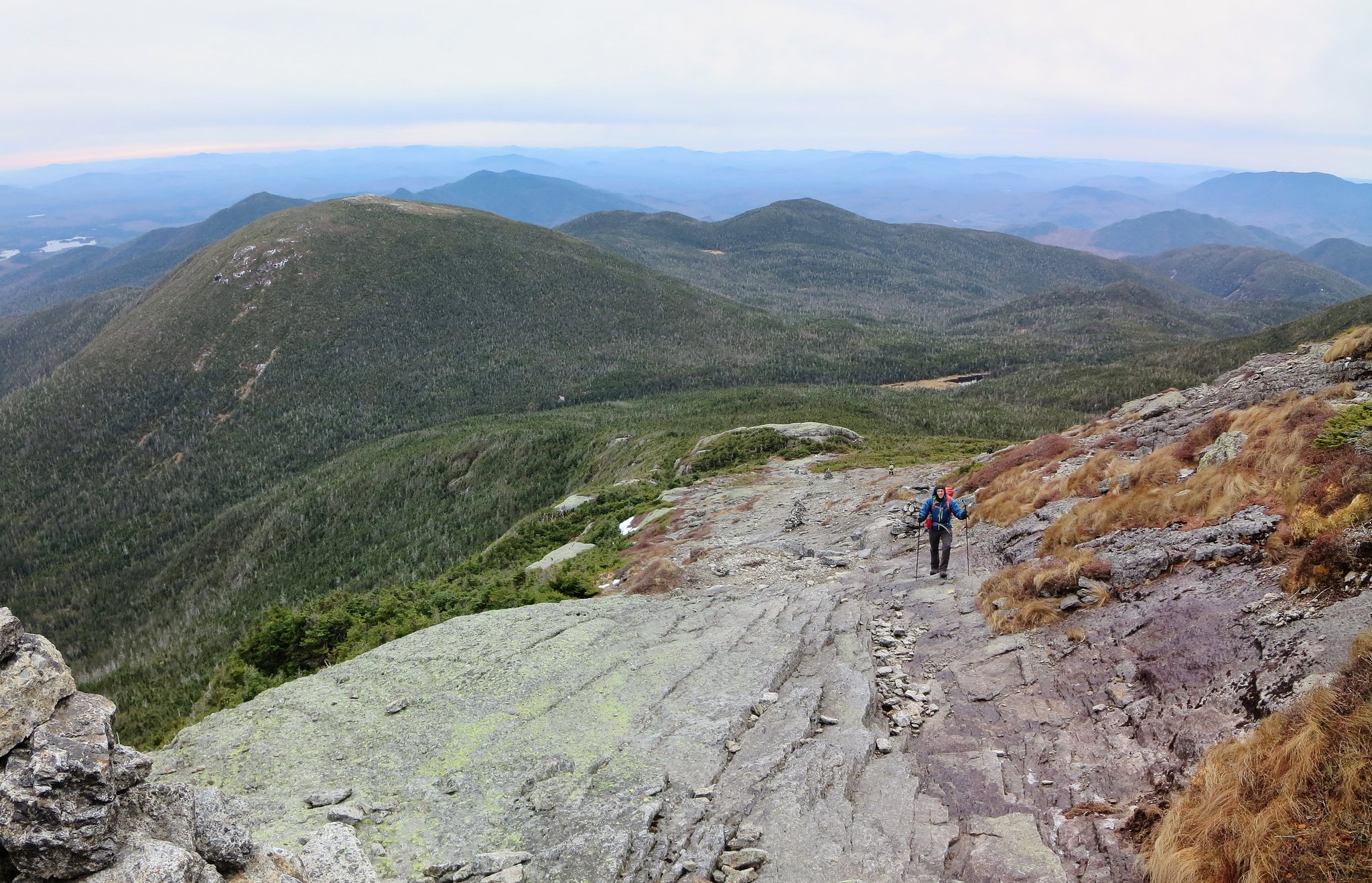
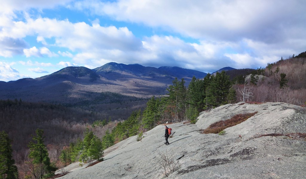
We re-entered the seemingly manicured woods and continued through airy pine, spruce, and birch. With a wealth of views to be found along its shoulder, Iron's summit was somewhat anti-climactic. Nevertheless, it provided us with our first unobstructed view of Owl Head and Green. Owl Head seemed close by but Green appeared to be uncomfortably far. Being only 10:00 AM, it was too soon to be concerned about running out of daylight.

Easy walking.
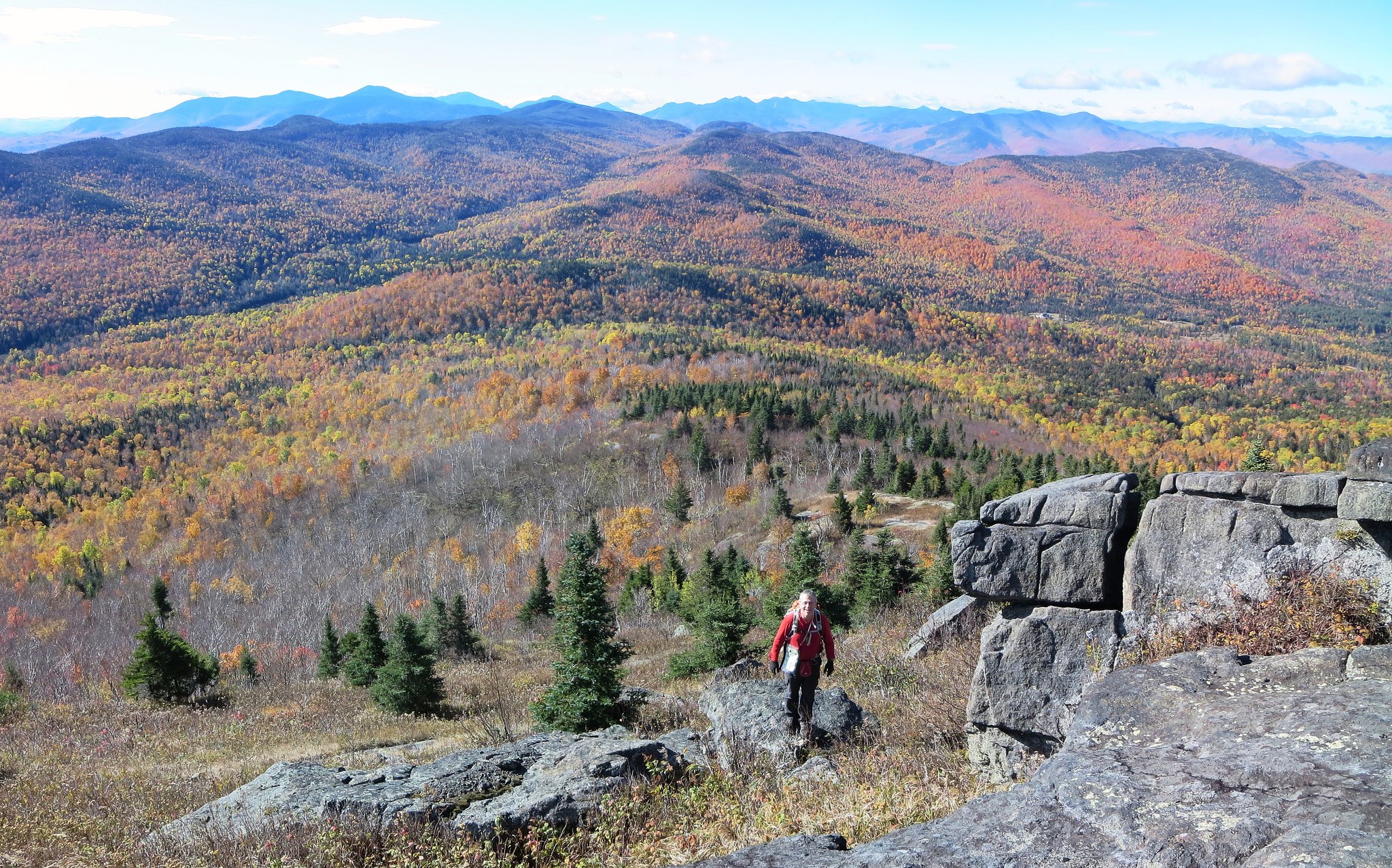
The next leg involved losing about 350 feet of elevation. The woods remained open but contained more underbrush and downed trees. In other words, it seemed more "normal" (to me). The lack of leafy trees worked to our advantage by allowing us to navigate visually. An unnamed peak, slightly taller than Iron, was our navigation marker. We kept it to our right and headed for a col on its south side. For anyone wishing to explore this area, I recommend heading directly for the unnamed peak. The terrain beyond the col required steep "side-sloping" across a drainage that could've been avoided by staying on high ground.

After climbing out of the drainage, the terrain returned to gentle slopes with broadly spaced trees and a deep carpet of leaves. Through the leafless trees we could see the outline of distant Bald and Rocky Peak Ridge. Its an outstanding place for anyone looking for an easy "bushwhack".
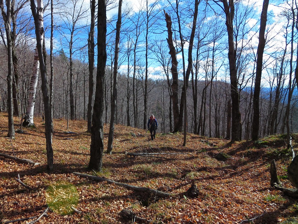
Park-like woods.
One final very short and steep ascent led to the summit of Owl Head Lookout. The last time I was there was May 25, 2015 
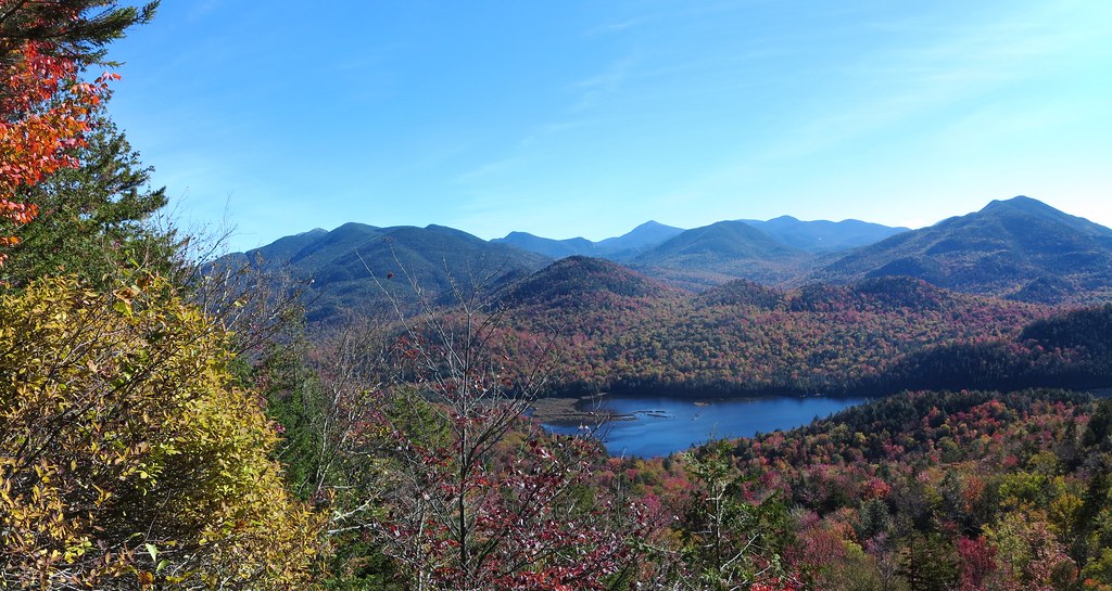
volunteering for ADK 46er trail maintenance. A late season snow storm made for miserably cold and wet conditions. Low lying clouds dominated the landscape. On this day, the weather was excellent and we were treated to a splendid view of the peaks that form the Roaring Brook valley. Green was now closer but revealed a significant ascent awaited us.

Owl Head Lookout.
We stopped for a short break. My right boot had been gnawing at my heel and created a nagging pain. I was concerned I had developed a blister but the skin was simply inflamed. I paused to apply a blister bandage reinforced with waterproof tape. Instead of trail-shoes, it was my first hike of the year wearing a pair of leather boots. Although they were broken-in, my feet preferred the fit and flexibility of my well-worn trail-shoes.

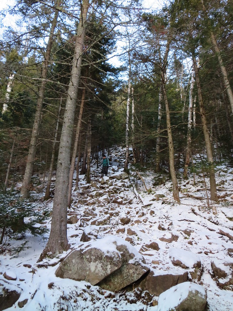
After a quick snack, and several photos of our intended destination, we made the short descent to the North Trail. We followed it for a few yards and then cut into the woods. The conditions became decidedly more "Adirondack" and we were greeted with thick firs and downed trees. Fortunately, it was short-lived and soon we were moving along at a good clip.

We had studied our route from Owl Head Lookout but nothing prepared us for the rocky knob we named "Owl Head Two". Lying a half-mile west-southwest of Owl Head, "OH2" stands a few yards taller than OH1. Its south side is steep, exposed rock and, with limited daylight, we chose not to ascend it. However, it appears to be well worth one's time to explore. The col west of OH2 is a rugged place littered with huge boulders.

The rocky knob we called "Owl Head 2".
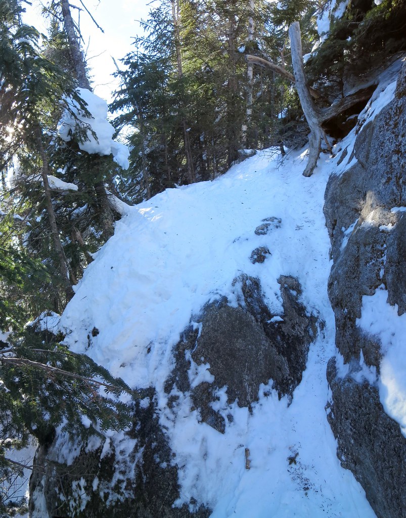
What grabbed our attention was the steep slope on the opposite side of the col. It was the start of a 600 foot climb to the top of the eastern end of Green's ridge. Hidden between the map's contour lines, gray walls of rock peaked through the firs and tacitly said "None shall pass!"

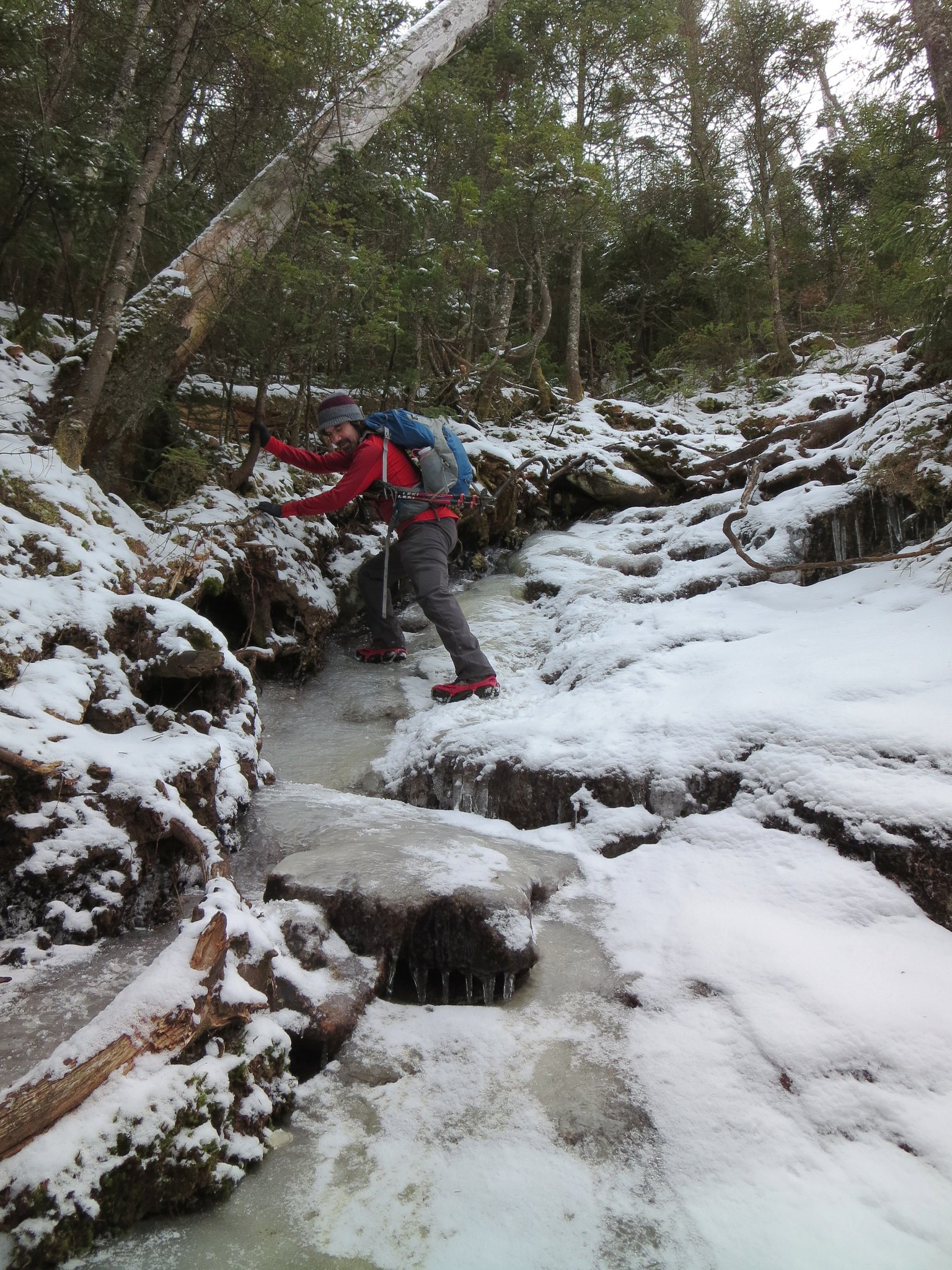
We contemplated skirting them by either heading north, to the col's height-of-land, or south, deeper into the drainage. We chose to get a closer look and discovered we could thread a route between the cliffs. Whereas navigation was easy, scrambling up the steep slope was not.

After clearing the steepest section, we breathed easy and settled into a steady rhythm. The sun was now lower in the sky and our route ran in the cooler shadows.  We noticed the first signs of snow accumulation. It looked like rock salt and it seasoned the moss and fallen leaves. Upon reaching the top of the climb, we re-joined the warm, sunlit, snow-free side of the mountain.

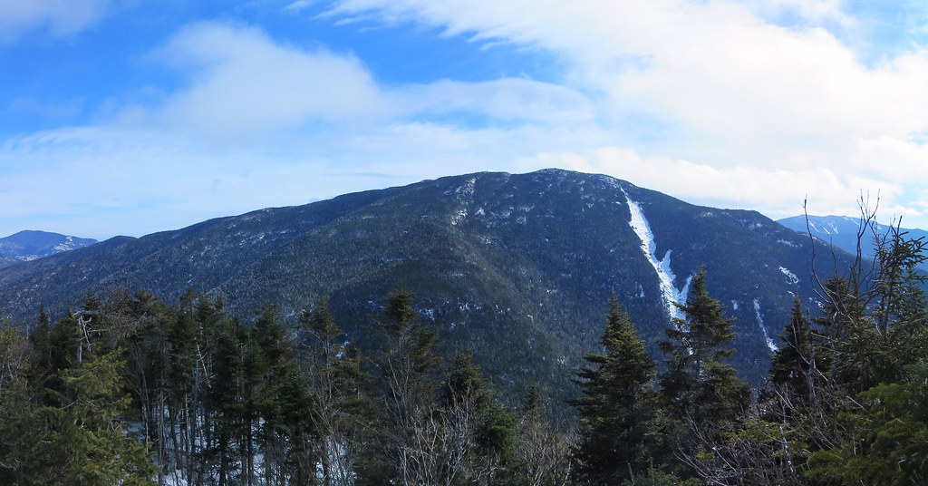
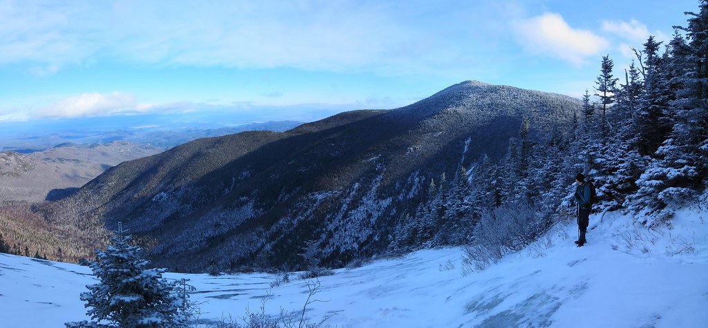
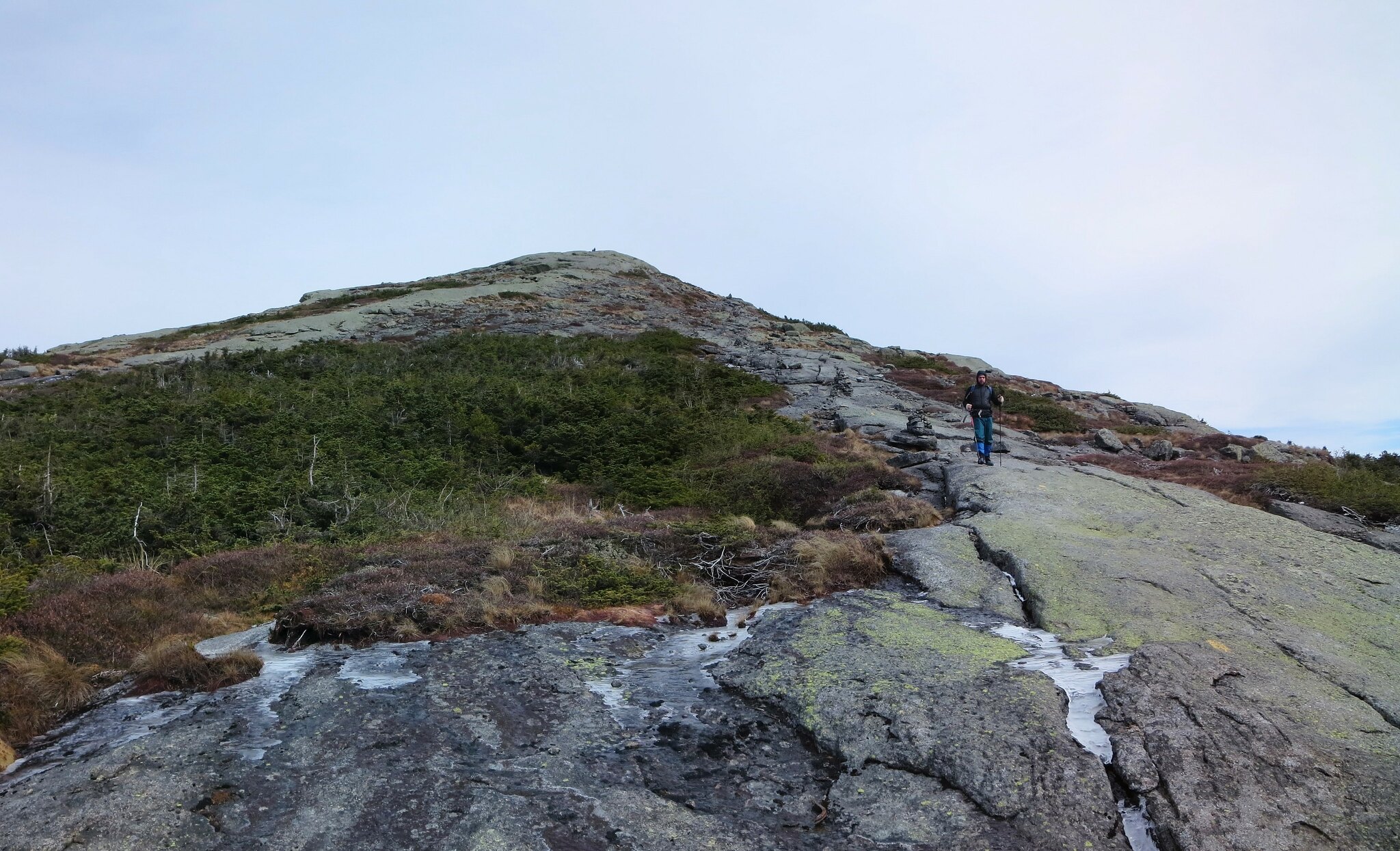
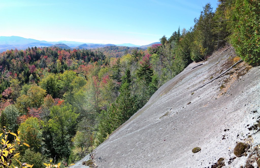
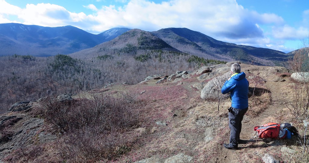
The next half-mile was a treat. Rising only 100 feet over its length, it is covered in tall grass, (prickly) underbrush, and sparse trees. Standing 900 feet above High Bank (on the North Trail), it offers unimpeded views of Roaring Brook valley and the ridge running from Bald to RPR and on to Giant. A braided game trail runs its length. It is also the last stretch of open woods along Green's ridge. The last mile to the summit is the typical Adirondack terrain one finds above 3000 feet, namely an abundance of conifers and blowdown.

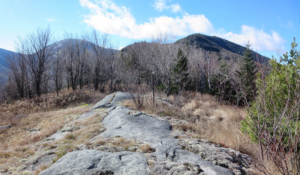
Beautiful open woods along Green's ridge.
After savouring the last view we'd see for awhile, we pushed into the woods and began the slow grind to the summit. The final mile rises about 800 feet and it took us a little over 1.5 hours to traverse.  I had to stop one more time to tend to my right foot. The bandage had slipped off and the heel pain had become impossible to ignore. A fresh layer of tape and a dry sock made a world of difference.

Attempting to remain exclusively on the ridge's centerline became difficult. We dropped a few yards down the north side where we found a steep slope but open woods. I also got a peek of rocky Knob Lock mountain. Neil explained it was well worth a visit and could be incorporated into a trip to Green from route 9 (as he had done in the past).

I didn't expect much from Green's summit. It is completely wooded, quite flat, and, despite relatively open woods, no views. We had followed a game-trail/herd-path but it did not lead to a marked summit. Unlike many other peaks, I found no sign, leftover canister mountings, blaze, flagging, cairn, trodden patch of ground, or other evidence of a "herd-summit". To stand atop a peak that hasn't been marked is both satisfying and perplexing; you felt like the first person to reach it or like someone who simply hadn't found the true summit.

After scouting the area, I settled on a mossy boulder to represent the highest point even though some nearby ground seemed equally tall. I'm not sure why I bothered but it seemed important at the time. The ground was bleached white by a thin blanket of snow and the late-afternoon sun streamed in through the trees. It was the best Green could muster to welcome us to its summit and it was appreciated.

Green's approximate summit.
Our descent route seemed like a no-brainer: head south and join the North Trail. Within a few yards our progress was halted by a field of blowdown. We had no appetite for it. We backtracked east, approximately 300 yards, and tried again. It was a good strategy because it permitted us to skirt the blowdown (confirmed later using a satellite image) and find friendlier woods.

A quick check of the map showed a drainage running down Green's south face. It intersected the North Trail about a half-mile east of  Giant lean-to. We knew there were cliffs so we bet on the drainage to create a navigable path through them. The gamble paid off. We easily threaded our way through the steepest sections and dropped 1000 feet over 0.6 miles in 45 minutes (~2 mph) which is a respectable clip for bushwhacking.

Upon intersecting the North trail we paused to strip off layers, have a bite, and prepare for the final five mile trail-walk back to my car. There would be a 450 foot ascent beyond High Bank but until then it would be an easy-peasy gradual descent along a smooth trail. We wouldn't exit before sunset but we would cover the five miles in two hours.

At High Bank we met the only other hiker of the day. I believe his name was Bob and he had just returned from the base of the slides on Giant's east face. A resident of Lake Placid and an avid backcountry skier, he had lost a ski while descending the slides a few years ago. He returned to explore the area and, for fun, attempt to locate the lost ski. We spent several minutes chatting with him and he recounted many examples of what experienced local skiers had accomplished in the High Peaks.


It was now close to 4:00 PM and sunset was a mere half-hour away. Bob joined us and we chatted all the way back to the car. The final 450 foot ascent to the Owl Head junction did not go by unnoticed. After a steady climb the grade diminished and I thought the junction to Owl Head Lokout must be just a few yards away. I looked up and saw, illuminated by the day's last dim light, Owl Head about a half-mile away. Well darn! I forgot there was a brief high-point before the trail descended into a drainage and rose to meet the spur-trail to Owl Head. We passed the junction at sunset.

A half-hour past the junction, twilight was lost so we stopped at Slide Brook to don our headlamps. The remaining mile flew by in the darkness. At the trail-head we thanked Bob for his company and said our goodbyes.

Neil and I proceeded with our usual post-hike preparations for the drive home (change into clean clothes, bag and stow dirty gear, retrieve wallets and passports, inspect ground for dropped items, etc). We made one quick stop at Stewarts in Elizabethtown to replace lost calories and fill up with comparatively cheap US gasoline (US$2.45/gallon or, at 35% exchange rate, CDN$0.87/liter vs $1.10/liter in Montreal). Under a clear and starry sky, we drove home while recounting the amazing things we had seen. Visiting Green by way of Iron and Owl Head is a wonderful hike.

Stats

Distance: 12 miles.
Ascent: 4850 feet.
Time: 9h 37m.

Photos

My photos.
Neil's photos.

Saturday, October 24, 2015

Thursday, October 15, 2015

Thursday, October 8, 2015

Henderson Traverse. 2015-10-08

Neil suggested we hike to the summit of Henderson from its eponymous lake rather than, the more common approach, from Bradley Pond. It would give us the opportunity to visit the lake and to explore an intriguing cliff on Henderson's eastern slope. From the summit, we could choose between returning to the lake or descending Henderson's western slope to Bradley Pond.

We left the Upper Works trail-head at 8:00 AM under a clear and sunny sky. The woods were damp and the fall foliage was at its peak. The trail-signs appeared to be relatively new and clearly spelled out destinations such as the Henderson Lake Dam, Duck Hole, and Mount Marcy.

The trail to Duck Hole was interrupted by a mirror-smooth beaver pond. We crossed it along a precariously spongy beaver dam. The bridge across Indian Pass Brook was surprisingly slippery. Its damp boards had frozen but showed no evidence of slickness until one's first step.

Surprisingly slippery footbridge.
We followed the side-trail to Henderson lean-to and were impressed by its location. The lean-to itself is in excellent shape, of the "Lincoln Logs" variety, and is neat as a pin. From the lake's shore we watched the morning's mist rise against the backdrop of fiery autumn colors. Nearby is a brook and we crossed it above a small waterfall to begin our bushwhack to the cliff.

Mist on Henderson Lake.
The terrain was rumpled and caused us to ascend and descend a few times before finally smoothing out. We didn't know it at the time but we arrived slightly north-east of the cliff. Sighting a "hole in the canopy", we moved south-west and arrived at the base of the cliff.


Route of our exploration of the cliff.
 The portion we could see rose 40-50 feet to an overhang.  Its otherwise smooth face was scarred by a right-leaning, class 4 ramp that beckoned to be climbed. I scrambled up high enough to concede my footwear and the wet rock made for a bad combination. I carefully down-climbed to the base and followed Neil who had started ascending the steep woods bordering the cliff's left side.

Fifty-foot cliff.
We found, but did not follow, a dicey route to the top of the overhang. We continued to ascend and found a smaller cliff with a narrow grassy shelf leading to a single bush. We stepped out onto the shelf and were rewarded with a clear view of the High Peaks and Henderson Lake. Although it was possible to traverse the cliff to rejoin the woods, we agreed it was too "exposed". We retreated the way we came, entered the woods and continued to climb.

View from cliff.
The woods bordering the top of the cliff were dense and obscured all views. We probed the margins but could not find a safe vantage point. We traversed to the right side and found a reasonably safe spot to emerge onto the slab. The view was worth the effort.

Slipping is not an option.
For the next leg, we ascended to ~2600 feet and were fortunate to find relatively open woods. We followed the stripe between two contour lines and marveled at our good luck. The land rose steeply to our right and dropped precipitously to our left. It was going so well that it seemed self-evident that we would return via this route rather than traverse to Bradley Pond.

We descended to an intermittent stream and then everything changed. It's normal for the woods to be denser near a source of water but they simply refused to thin out. Wherever they did it was either short-lived or due to a blowdown field. Our progress slowed to a crawl. It became increasingly difficult to flank the blowdown fields because they seemed to have no perimeter. My gnarlometer registered a new high-water mark.

While clambering over several fallen trees, I reflected on how my perception of difficulty had changed. This was my fourteenth bushwhacking trip in 2015 and what once caused trepidation now instilled stoicism. It is what it is, so just keep moving because it can't last forever (it only feels that way). Our doggedness was rewarded by excellent views of Wallface from blowdown clearings.


Wallface and McIntyre Range.
Nearing the summit, the blowdown diminished and the relief was palpable. It was clear we would not be returning the same way. It had taken us 2 hours to cover 0.6 miles and climb 1000 feet. It was a new personal record for 'least miles per hour'.

The summit offered no views. I climbed a fallen tree to get a partial view of the High Peaks. We paused briefly for a snack and then began our descent to the Santanoni lean-to (aka Bradley Pond lean-to). Our descent route was a welcome change from our ascent route. Henderson's western slope was mercifully free of blowdown. Forty-five minutes later, we intersected the marked trail slightly north of the lean-to.

Yard-sale at Santanoni lean-to.
The last time I saw the Santanoni lean-to was in 1982. I have a vague recollection of having a view from the lean-to. According to the High Peaks guidebook, the lean-to was moved uphill. In 2015, there is no view but it seems like everyone is trying to re-establish one. The lean-to is surrounded by dozens of foot-tall stumps, tacit evidence of cutting live trees. This illegal activity was aided by a hand-held "Means of Destruction" hanging from a nail. Good luck finding it now.

The air of 'backcountry slum' was enhanced by a rumpled pile of tarps and discarded items like an adze and a sleeping bag. The fire-pit had the usual assortment of burnt and unburnt garbage. It was the polar opposite of the pristine Henderson lean-to.

Both of us had seen the Bradley Pond trail several times so we shifted into high gear and cleared the 4.4 miles in under 90 minutes. Along the way we found a hat and evidence of recent passage. We emerged at the Santanoni trail-head and caught up to two separate hikers preparing to leave.

Apparently the hat belonged to neither of them. However, its owner was known and we were instructed to deposit it on the "blue car". Both hikers graciously agreed to give us a lift to Upper Works and we accepted the first offer. I congratulated the younger hiker who had just completed his ADK 46 on Couchsachraga.

Back at Upper Works, we changed into clean clothes and made one sight-seeing stop at the McIntyre Iron Furnace before settling in for the 3 hour drive home. The balance of our trip was spent ogling the brilliant fall colors from the comfort of the car. Memories of Henderson's gnarly western side were already fading into the distant past.

9 miles and 3300 feet.

Photos

See all photos.